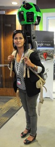
All-seeing: Google’s Street-View Trekker backpack camera
 For all its planes and vans mapping out the world, there have been places even Google cannot reach.
Now thanks to its latest weapon, the internet giant will be able to chart everywhere from the depths of the jungle to the narrowest city alley.
Its backpack camera, which is carried by a trekker on foot, will be able to get to places that Google wings and wheels cannot. The device, a more portable version of its controversial Street View cameras, is able to go ‘offroad’, potentially photographing and mapping everywhere from the base of the Grand Canyon to the top of Everest.
Campaigners have warned that privacy risks being sacrificed in a commercial race between Google and its rival Apple, which unveiled its latest mapping technology yesterday.
The two are competing to produce three-dimensional maps and have deployed spy planes to photograph streets and homes. The planes will be able to operate in British skies without special licensing or permits. Google has also used its Street View cars to gather ground-level panoramic photographs.
Once products are launched, state-of-the-art technology will allow iPhone and computer users to access 3D maps based on high-resolution photographs so detailed they can reveal objects just four inches across.
Google said its new Street View Trekker backpacks, which took more than a year to develop, were ‘another step forward’ in its plans to produce an interactive and comprehensive map of the world. The 40lb backpack holds up a number of 15-megapixel cameras, an on-board hard drive, and enough battery to run for an entire day.
Cameras are positioned to give a 360 degree view so every possible angle is captured. At the launch earlier this month, the US company said: ‘There’s a whole wilderness out there that is only accessible by foot.
‘Trekker solves that problem by enabling us to photograph beautiful places such as the Grand Canyon so anyone can explore them.’ Google said only a handful of the backpacks had been made so far and it has not yet revealed if it intends to manufacture more. Google expects to have 3D map coverage of towns and cities with a combined population of 300million by the end of this year.
Last night, Apple announced the launch of its controversial rival to Google Maps, which will offer 3D capability and a ‘flyover’ mode that gives users an aerial view of major cities.
And in a development that could raise more questions about privacy, the company said its maps would use ‘anonymous, real-time data’ collected from iPhones to monitor traffic – without telling users what it was doing.


